All new - discover our map

vanlifezone

Hello, fellow adventurers and van life enthusiasts! We at Vanlifezone are thrilled to pull back the curtain on our newest creation that's been in the making: our interactive global map, now live and ready to enrich your travels at www.vanlifezone.com/map!

Our journey began with a vision to craft a tool that wasn’t just a map, but a bridge to a world of van life possibilities. We've meticulously designed this map to not only provide practical solutions but also to inspire you to explore further and with greater confidence.


The world is vast and your spirit for adventure, boundless. Our map is your compass to navigate this beautiful planet we call home. From the essential — like drinking water, public toilets, and laundromats — to the experiential — such as campgrounds and outdoor stores — our map is an ever-expanding collection of resources. We have taken care to list amenities that cater to the unique needs of the van life community.


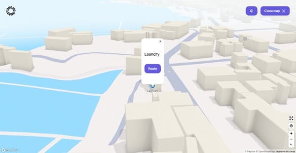
A 3D interactive city map from Vanlifezone, featuring a simplified representation of an urban layout with block-like buildings and blue water. A pop-up on the map highlights a 'Laundry' location with a 'Route' button to guide users to the service. The interface includes a 'Close map' button and map navigation tools to the right, as well as a Mapbox and OpenStreetMap attribution in the lower right corner, indicating the map's source.
A laundromat near you - vanlifezone.com/map


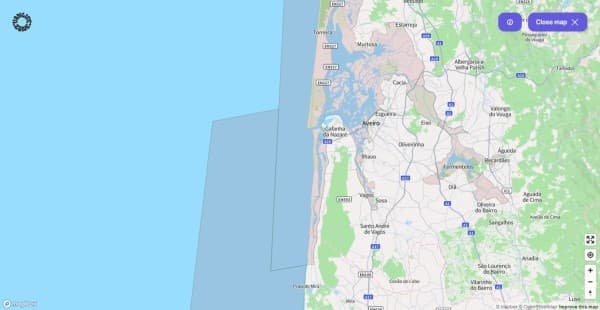
We understand the allure of the path less taken, and for our European wanderers, we've integrated Natura 2000 areas to ensure your exploration is both adventurous and respectful to the natural world.


Map section from Vanlifezone displaying a Natura 2000 environmental protection area in Portugal. The highlighted zones are illustrated in a lighter shade, contrasting with the surrounding terrain. Cities such as Aveiro, Gafanha da Nazaré, and Praia de Mira are visible, along with various road networks including A1, A17, and A25 highways. The map features a blue ocean backdrop, a 'Close map' option in the upper right corner, and Mapbox and OpenStreetMap attributions in the bottom right, indicating the map's sources and contributions.
"Natura 2000" protected areas in Portugal - vanlifezone.com/map


Quite often, we hear about vanlifers in Portugal or other European countries who were fined around 250€ simply for parking in one of those zones. Since protecting the environment and ensuring a great traveling experience are our top priorities, our map should help you stay clear of those areas! We’re aware that there are way more protected zones inside and outside of Europe, so rest assured that we’ll add more resources in the near future!


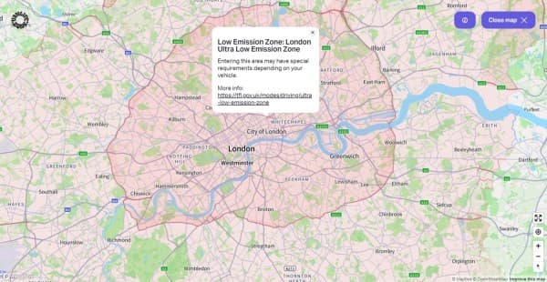
Interactive map view from Vanlifezone highlighting the Low Emission Zone in London, with the Ultra Low Emission Zone clearly marked in pink overlay. Key areas such as the City of London, Westminster, Greenwich, and surrounding neighborhoods like Brixton, Chiswick, and Edgware are visible. The map includes river details, road networks like the A40 and M1, and green spaces throughout. An information pop-up provides details about the emission zone and a link for more information. Navigation tools and a 'Close map' button are included, along with Mapbox and OpenStreetMap credits.
Low emission zone in London - vanlifezone.com/map


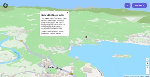
3D interactive map view from Vanlifezone near Lake Bled in Slovenia, highlighting a Natura 2000 Zone in Julijci. The map shows rolling green hills and a large blue body of water with a pop-up information box describing the area's environmental significance and camping regulations. It includes the names of local rivers like Sava Dolinka, roads, and landmarks. A 'Camp Site' icon indicates a nearby camping area. The map features user interface elements like a 'Close map' button, and zoom controls, with Mapbox and OpenStreetMap credits in the corner.
3D view near lake Bled in Slovenia with a "Natura 2000" pop-up - vanlifezone.com/map


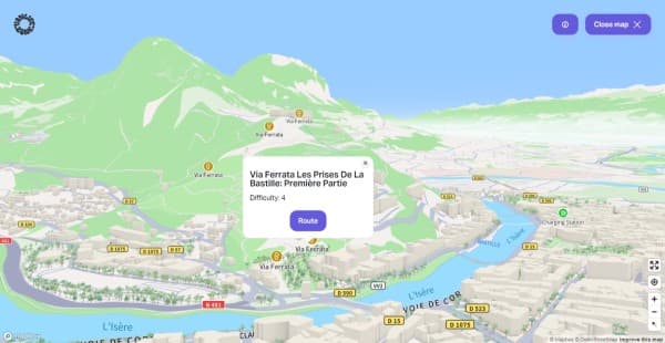
And it’s not just about where you can or cannot go, but also about the journey. With our state-of-the-art 3D view, you can traverse mountains, valleys, and cities with a clarity that feels as real as the road beneath your wheels. Simply jump to your location, enter the 3D view, and see how high you’ll have to climb to reach your nearest public toilet or a via ferrata. With a simple right-click and drag on your desktop or a two-finger swipe upwards on your mobile device, you can explore the terrain as if you were already there. Experience our map's smooth performance, designed to keep up with the pace of your travels, because we know that a seamless experience is crucial when you're chasing the horizon.


Interactive 3D map from Vanlifezone featuring the Via Ferrata Les Prises De La Bastille route in Grenoble, France. The map shows a detailed terrain of green mountains and the city's layout with buildings in relief, roads like D57 and D590, and the blue river L'Isère. A pop-up provides information on the Via Ferrata route, including the difficulty level, with a 'Route' button for navigation. Icons for Via Ferrata and a charging station are visible, aiding in adventure planning. The interface offers a 'Close map' feature and has Mapbox and OpenStreetMap attributions.
3D view of Grenoble, France with via ferratas - vanlifezone.com/map


And the best thing: all of this is available for free for everybody to use on our website! You can even add our website to your Home screen and use it like a native app on your device. All that said, we're just getting started. The map is brand new, and with your feedback, it will continue to evolve. This is an open invitation to be part of the Vanlifezone experience — to contribute, to share, and to connect with the global van life community. We’re all ears for your feedback!


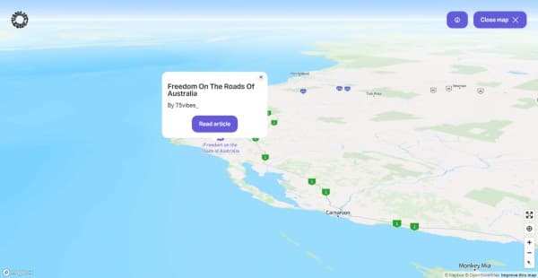
Interactive map from Vanlifezone featuring the coastal region of Western Australia with a focus on road travel. A pop-up window is displayed, promoting a journal article titled 'Freedom On The Roads Of Australia' by @75vibes_. The 'Read article' button within the pop-up links to the article in our journal online. The map shows key locations such as Port Hedland, Tom Price, and Monkey Mia, with a vast ocean backdrop. Navigation tools are present for user interaction, and the map credits Mapbox and OpenStreetMap in the corner.
A link to @75vibes_' article in our journal - vanlifezone.com/map


We're proud to offer this tool and we invite you to immerse yourself in its capabilities. Visit us at vanlifezone.com, where our map is just the beginning. Explore our journal, get to know our team, and become a part of the story that we’re all writing together—one of freedom, adventure, and the open road.


About Vanlifezone
Vanlifezone - sharing vanlife stories and adventures out of passion
More articles